

Rio de Janeiro, Brazil
Rio de Janeiro, in full Cidade de São Sebastião do Rio de Janeiro, byname Rio, city and port, capital of the estado (state) of Rio de Janeiro, Brazil. It is located on the Atlantic Ocean, in the southeastern part of the tropical zone of South America, and is widely recognized as one of the world’s most beautiful and interesting urban centres. Although Rio de Janeiro continues to be the preeminent icon of Brazil in the eyes of many in the world, in reality its location,
architecture, inhabitants, and lifestyle make it highly unique when compared with other Brazilian cities, especially the country’s capital of Brasília or the much larger city of São Paulo. The former is a much smaller city dating back only to the 1960s, while the latter is a huge, sprawling commercial and manufacturing centre with none of Rio’s spectacular natural beauty or captivating charm. Unlike Rio, both are located on flat interior plateaus.
The name was given to the city’s original site by Portuguese navigators who arrived on January 1, 1502 and mistook the entrance of the bay for the mouth of a river (rio is the Portuguese word for “river” and janeiro the word for “January”). When the foundations of the future town were laid in 1565, it was named Cidade de São Sebastião do Rio de Janeiro (“City of St. Sebastian of Rio de Janeiro”) for both São Sebastião and Dom Sebastião, king of Portugal.
Rio de Janeiro became the colonial capital in 1763 and was the capital of independent Brazil from 1822 until 1960, when the national capital was moved to the new city of Brasília; the territory constituting the former Federal District was converted into Guanabara state, which formed an enclave in Rio de Janeiro state. In March 1975 the two states were fused as the state of Rio de Janeiro. The city of Rio de Janeiro became one of the 14 municipalities of the Metropolitan Region of Rio de Janeiro, or Greater Rio, and was designated the capital of the reorganized state. Despite loss of the status, funding, and employment it had enjoyed as Brazil’s capital, Rio de Janeiro not only survived but thrived as a commercial and financial centre, as well as a tourist magnet. Area city, 485 square miles (1,255 square km); Greater Rio, 2,079 square miles (5,384 square km). Pop. (2000) 5,857,904; Greater Rio, 10,894,156; (2010) 6,320,446; Greater Rio, 11,875,063.
Character of the city
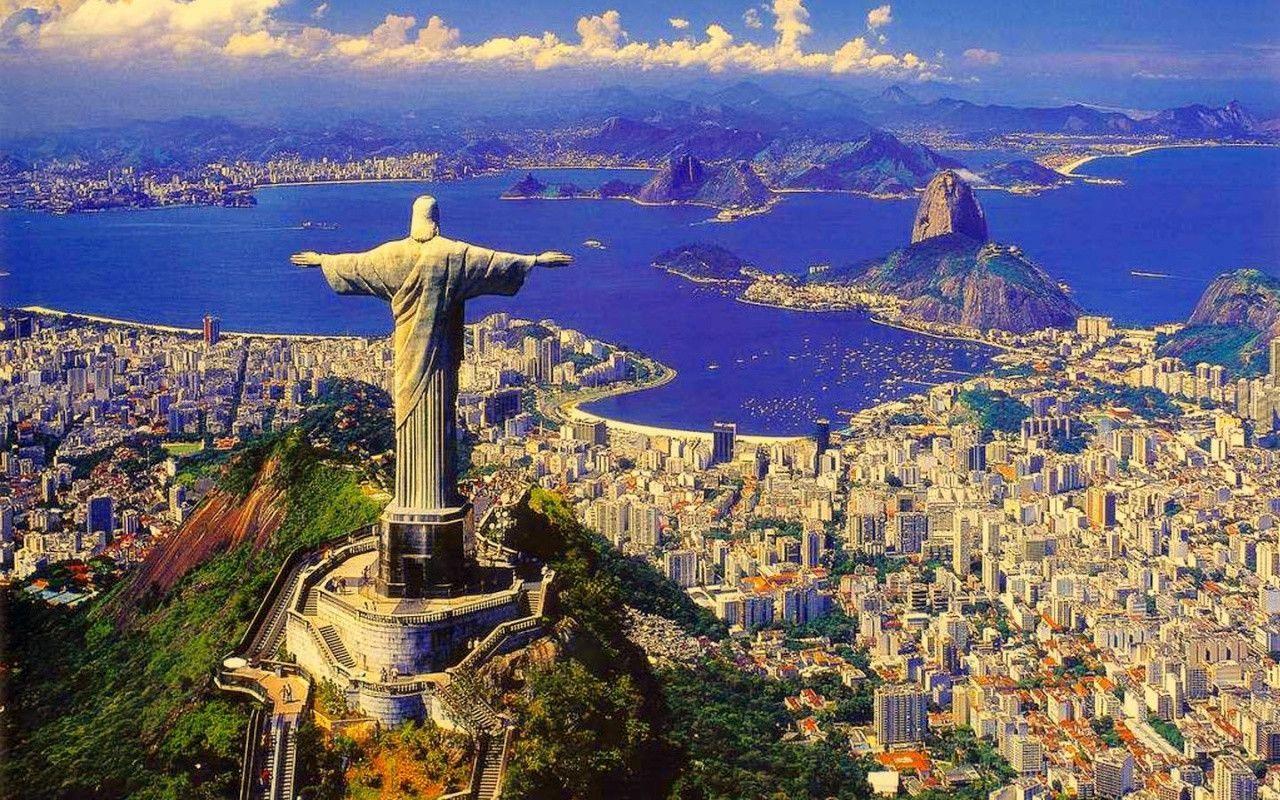
Rio de Janeiro is well known for the beauty of its beaches and of its peaks, ridges, and hills—all partly covered by tropical forests. The city is a centre of leisure for Brazilian and foreign tourists, and people wearing bathing suits can be seen walking in the streets and along the beaches or traveling on the city’s buses. Perhaps at no time is the city’s festive reputation better displayed than during the annual pre-Lenten Carnival, which enlivens the city night and day with music, singing, parties, balls, and street parades of brilliantly costumed dancers performing to samba rhythms. Rio is also an important economic centre, however, with activities ranging from industry and national and international trade to administration, banking, education, culture, and research.
The city’s economic and social prominence grew in the 18th century after it became the main trade centre for the gold- and diamond-mining areas of nearby Minas Gerais. Later its status as a national capital and as the royal residence of the Portuguese monarch influenced Rio’s continued growth and helped it acquire a cosmopolitan atmosphere and a national character, free of regional conflict. After the city was relegated to being a state capital in the mid-20th century, however, a new regional consciousness began to develop. While São Paulo became entrenched as Brazil’s economic heartland and Brasília strengthened its position as the political hub, residents of Rio increasingly prided themselves on being the country’s cultural centre and Brazil’s most salient symbol to the rest of the world.
People of Rio de Janeiro
Rio’s inhabitants (called Cariocas, after the Tupi Indian word meaning “white man’s home”) represent a microcosm of Brazil’s ethnic diversity and include people of European, African, and mixed ancestry. In Brazil, people of African descent (referred to as “Afro-Brazilians” by outside scholars) can be further characterized using such terms as pardos and pretos; the latter term is used to refer to those with the darkest skin colour. Although skin colour is largely the basis of the distinction between pardo and preto, it is a distinction that is subjective as well as objective, and it is self-attributed.
Many Brazilians of color consider it more advantageous to identify themselves as pardos and therefore do so. About one-third of Rio’s pardos are clearly mulattoes (mulatos; people of mixed African and European ancestry), while the vast majority of the city’s small preto population do not claim any known European ancestry. Cariocas are primarily Roman Catholic, although many simultaneously observe the practices of the Umbanda religion (see Macumba).
People of European ancestry live predominantly in the affluent neighbourhoods of Flamengo, Copacabana, Ipanema-Leblon, Jardim Botânico, and Gávea in the South Zone; in Tijuca in the North Zone; and stretching from Barra da Tijuca past Recreio dos Bandeirantes in the West Zone. The northern suburbs, in contrast, contain much larger proportions of mulattoes, as do many districts of the North Zone. The heaviest concentrations of pardos and pretos are found in Rio’s favelas, regardless of location. The rich mosaic of areas of the North Zone are socially differentiated by the average level of income of their inhabitants, closely reflected in the urban infrastructure and public services that are locally available. While the ring of neighbourhoods closest to the Centre is deteriorated, the next ring contains more-prosperous areas. Farther out, however, poverty increases. Both distance from the Centre and elevation serve as determining factors for the location of favelas, since they have been established on all available steep hillsides as well as in undesirable swampy lowlands throughout the Greater Rio area.
Historically, Rio’s population grew primarily as a result of domestic migration, which in some years accounted for two-thirds of the city’s increase, although many people immigrated from European countries as well. Government policies began restricting foreign immigration in the 1930s, causing the proportion of foreigners in the former Federal District to decline from 30 percent in 1890 to 7 percent in 1960. By that time, almost half of the city’s population were Brazilian migrants, most of them born in the states of Rio de Janeiro, Minas Gerais, and Espírito Santo. The largest groups of foreign-born immigrants in the Greater Rio area included those from Portugal, Italy, and Spain.
The 1950s were Rio’s decade of greatest proportional growth, with the city expanding by nearly 40 percent and the suburbs almost doubling. However, with the transfer of the national capital to Brasília in 1960, the rhythm of population growth in the city declined. Most internal migrants were directed to other municipalities of the metropolitan region, leaving Rio to rely more on the birth rate within its own boundaries. Still, the city’s population grew steadily and did not begin to taper off until the 1990s, when Rio’s limited space—then near saturation—served to restrict further growth. With improved access to the West Zone beginning in the late 20th century, growth again began to pick up.
At the beginning of the 21st century, more than four decades since Rio ceased to be the national capital, a large proportion of federal employees were still based there, along with tens of thousands of state and city workers. Moreover, retirees from public service jobs continued to constitute a significant element of Rio’s population.
History
The colonial period
Several years after the Portuguese first explored Brazil, French traders in search of pau-brasil (a type of brazilwood) reached the rich area extending from the Cape Frio coast to the beaches and islands of Guanabara Bay—the economic and, above all, strategic importance of which was already well-known. On one of these islands, the French founded a colony that was called La France Antarctique (Antarctic France).
The Portuguese wanted to expel the French from Brazil, and the task was given to Estácio de Sá, a nephew of Gov. Mem de Sá of Brazil, who in 1565 occupied the plain between Dog Face Hill (Morro Cara de Cão) and the Sugar Loaf and Urca mounts, thus laying the foundations of the future town of Rio de Janeiro. After two years (1565–67) of bloody battles, in which Estácio de Sá was killed and the French expelled, Mem de Sá chose a new site for the town, farther inland on the coast of the bay, at the top of the Hill of Rest (Morro do Descanso), or St. Januarius Hill (São Januário), later called the Castle Hill (Morro do Castelo). In 1568 the settlement was laid out in the form of a medieval citadel, protected by a bulwark and cannons.
The surrounding fertile land, allotted to Portuguese settlers by the Portuguese king in enormous plots called sesmarias, was planted with sugarcane, which was to provide the colony with its main source of income. In 1660 the community became the seat of the government of the southern captaincies (Portuguese administrative units) of Brazil. In the second half of the 17th century, the captaincy population grew to 8,000 inhabitants, two-thirds of whom were probably African slaves and Indians.
At the beginning of the 18th century, Brazil began to engage in gold and diamond mining, which brought about remarkable changes in the colony’s economy and stimulated a great migration from Europe, thereby increasing the number of people of European ancestry. The former village became a town of 24,000 in 1749. When the colonial capital was transferred from Bahia to Rio de Janeiro in 1763, the town expanded farther, far beyond its walls. The remains of the monumental Roman-style aqueduct Arcos (“Arches”) built at this time still stand in the city.
At the end of the 18th century, the town’s economy, as well as that of the colony as a whole, was in a crisis because of the decline of the mines and competition from Central America for the world sugar market. In 1796 the value of exports from Rio’s port was less than half of what it had been in 1760.
Coffee production and the resettlement of the Portuguese royal family in Brazil in 1808 again brought prosperity to the colony. By 1815, when Brazil became a kingdom, Rio de Janeiro was large enough to accommodate a foreign population. At about that time the city’s original appearance was being transformed; from 1808 to 1818 some 600 houses and 100 country houses were built, and many older buildings were restored. Many streets were lighted and paved, more land was reclaimed, new roads were opened, and new public fountains were installed. Among new institutions established were the Royal Press, the Royal Library, the Theatre of Saint John, the Academy of Fine Arts, the Botanical Garden, and the Bank of Brazil. When King John VI returned to Portugal in 1821, Rio had almost 113,000 inhabitants and 13,500 buildings, and the town had extended both northward and southward. A year later Brazil was independent.
The city after independence
Expansion of coffee plantations in the state of Rio de Janeiro gave a new impulse to the city’s development. Nobles and bourgeois moved their residences north to the São Cristóvão district. Merchants and English bankers chose to live around the Outeiro da Glória and Praia do Flamengo areas in the south, or they established their residences in the nearby Botafogo and Laranjeiras districts. The French, on the other hand, lived in country houses scattered in the Tijuca area farther westward.
In that era, as Brazil expanded its world export trade in such products as coffee, cotton, sugar, and rubber, the city changed its appearance, and the traces of its colonial past were effaced. In 1829 oxcart traffic was banned from the Rua do Ouvidor, then the city’s most elegant street. In 1838 the first public transportation—horse-drawn buses—began to run to the districts of São Cristóvão, Engenho Velho, and Botafogo. In 1868 the first tramcars, also drawn by animals, were introduced. A steamboat service to Niterói began to operate in 1835. The first railroad was built in 1852 to Petrópolis, and a line reached Queimados in the Nova Iguaçú area in 1858. In 1854 gas replaced oil for street lighting, and wireless telegraphy was inaugurated. Sewerage was installed in 1864, and telephone service began in 1877.
The republican period
When Rio de Janeiro, which had formerly been the capital of the empire, became capital of the republic of Brazil in 1889, it was already a considerable community. At the time of the 1890 census, it had more than 520,000 inhabitants on 61 square miles (158 square km), ranking it as the largest city in Brazil and one of the larger cities in the world. The 1891 constitution designated it the Federal District.
Source: